

Maps & Atlases
Tübingen Atlas of the Near & Middle East (Tübinger Atlas des Vorderen Orients, TAVO)
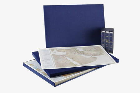
Archive Edition
295 sheets in two handmade blue cloth folders and 3 vols Index
Historical and Geograhical Atlas of the Near East; Masterpiece of German Academic Work. Complete set: 295 four color maps 500 x 720 mm in 2 blue cloth folders & 3 vols index....
more »
Tübingen Atlas of the Near & Middle East (Tübinger Atlas des Vorderen Orients, TAVO)
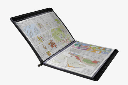
Portfolio Editiont for library use
295 sheets in 7 portfolios, each map in plastic sleeve, and 3 vols Index
Historical and geograhical atlas of the Near East; Masterpiece of German Academic Work. Complete set: 295 four color maps 500 x 720 mm. Part A, Geography & Cultural Anthropology, covers the geography of the Middle East, as well as climate, geology, settlement, religion and economy. Part B, History, covers all periods of history from the Stone Age, the Romans, the Expansion of Islam and the Crusades up to the times of Imperialism and Decolonization.The cartographic material can be accessed using the three index volumes. ...
more »
Tübingen Atlas of the Near & Middle East (Tübinger Atlas des Vorderen Orients, TAVO)
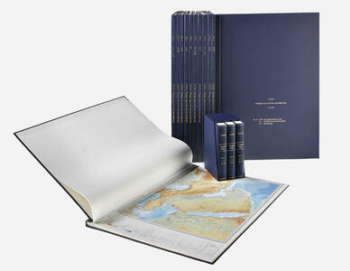
Hardcover Edition
12 vols and 3 vols Index
Historical and geograhical atlas of the Near East; Masterpiece of German Academic Work. Complete set: 295 four color maps 500 x 720 mm in hardbound in twelve volumes. Handmade by German bookbinder. Part A, Geography & Cultural Anthropology, covers the geography of the Middle East, as well as climate, geology, settlement, religion and economy. Part B, History, covers all periods of history from the Stone Age, the Romans, the Expansion of Islam and the Crusades up to the times of Imperialism and Decolonization.The cartogr...
more »
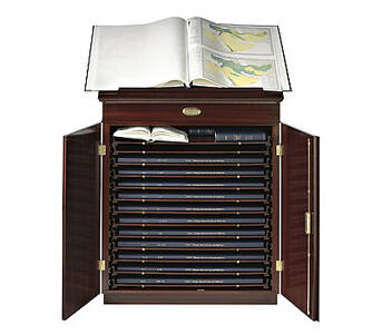
Map Cabinet for Tübingen Atlas of the Near & Middle East (Tübinger Atlas des Vorderen Orients, TAVO)
Hand crafted map cabinet with 13 drawers for atlas and index, 2 doors with lock, mahogany (or other) veneer, brass mountings, reading desk with leather inlay. Following the example of Napoléon’s famous “Déscription de l’Égypte” we have tailor made a cabinet for our twelve volume hard cover edition of the Tübingen Atlas of the Near and Middle East (Tübinger Atlas des Vorderen Orients or “TAVO”). Each cabinet is hand made. This elegant TAVO map cabinet can be used for transportation, storing and reading as it is equipped wit...
more »